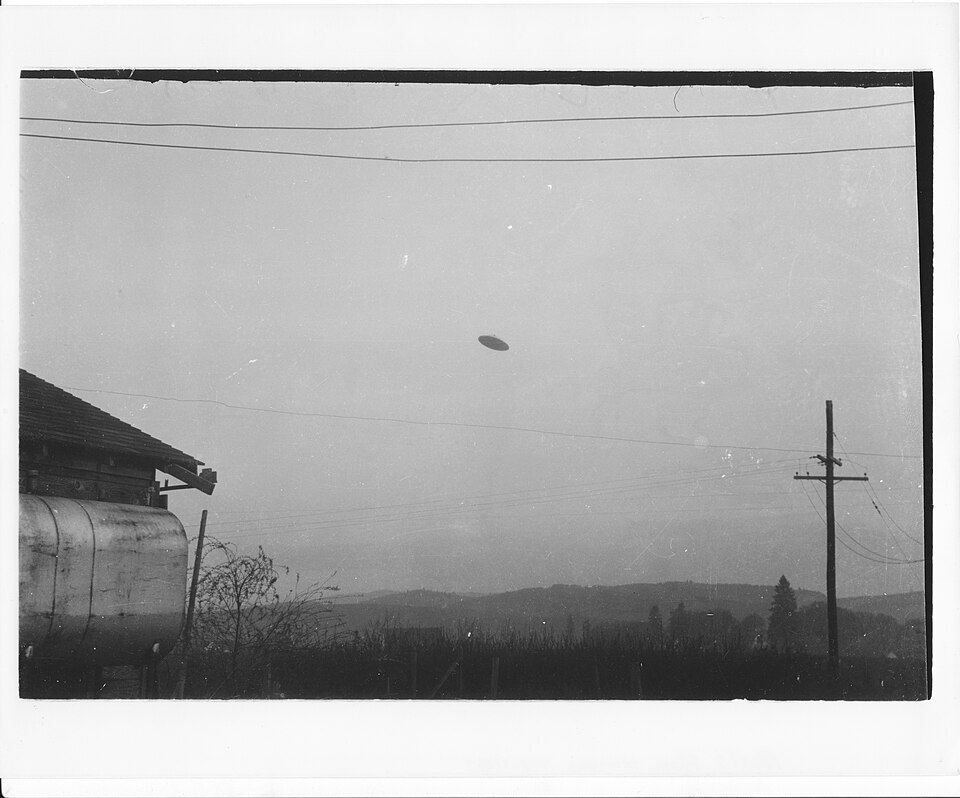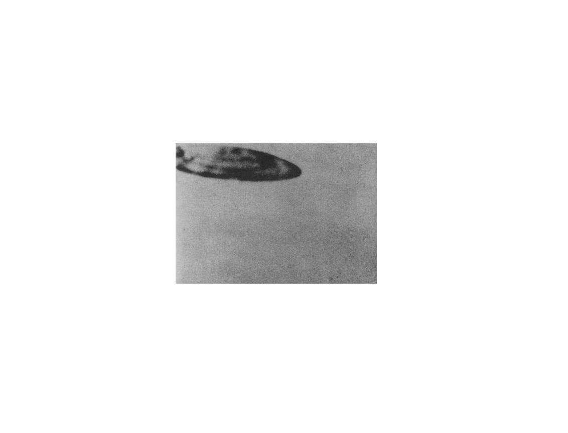
In 1953, a teenager in San Bernardino, California photographed a disc shaped object hovering near power lines in the area. The photograph shows a dark object with a disc or saucer profile positioned in the sky adjacent to utility infrastructure, with the power line structures providing reference objects that allow approximate scale and distance assessment within the image. The photograph was submitted to the U.S. Air Force and examined by Project Blue Book as part of the program's continuing review of civilian photographic evidence during the post 1952 period of active UAP documentation.
The San Bernardino photograph is one of a cluster of California UAP photographs from the early 1950s that collectively document unusual disc shaped objects photographed by civilian witnesses in the western United States during the peak of the early Cold War UAP wave. The Inland Empire region of Southern California, in which San Bernardino is situated, was in 1953 surrounded by a concentration of military and aerospace installations including Norton Air Force Base, March Air Force Base, and various aircraft manufacturer facilities in the greater Los Angeles basin. This aerospace density makes the region one in which both genuine anomalous aerial activity and potential misidentification of classified aircraft would be most likely to produce photographic records.
The witness being a teenager at the time of the encounter is a contextual detail that Blue Book investigators and subsequent researchers have weighed in different ways. On one hand, young witnesses without the professional aviation background of a military pilot or an experienced photographer might be considered less reliable observers for nuanced observational details. On the other hand, the photographic evidence stands independently of the witness's age, and the photograph itself is subject to the same technical analysis regardless of who held the camera. The combination of a photograph with witness testimony that identified the object as hovering near infrastructure provides both a visual record and a spatial and behavioral description.
The power line infrastructure visible in the photograph is potentially one of its most analytically useful features. Power lines and utility poles have known standard dimensions, the spacing between poles follows regulated engineering specifications, and the height of transmission lines above ground is a regulated parameter in California utility construction. If the power line infrastructure visible in the photograph can be identified and surveyed, the object's approximate angular size and therefore its possible physical size and distance range can be constrained with greater precision than photographs without known reference objects in frame allow.
The photograph was subsequently archived in the civilian UAP research community and is accessible through online photographic archives maintained by researchers who systematically documented Blue Book's photograph files before and after the program's closure. Its inclusion in searchufos.com's image collection ensures its availability to researchers despite the passage of more than seventy years since it was taken.
Project Blue Book's investigation of the San Bernardino photograph occurred during the program's post Robertson Panel period, when institutional pressure to produce conventional explanations had increased significantly following the CIA panel's recommendation to pursue systematic debunking of UAP reports. The 1953 operational context meant that photograph submissions received a somewhat different institutional treatment than those from the peak 1952 period, with the program now operating under a more explicitly debunking oriented policy framework.
The standard photographic analysis for cases of this type would have examined the object's apparent position relative to the power line infrastructure, the consistency of lighting and shadow conditions within the image, the object's edge characteristics and whether they were consistent with a physical three dimensional object or showed signs of photographic manipulation, and whether the object's shape corresponded to any known aircraft type or common object that might produce a disc shaped silhouette when photographed in certain orientations.
Power line proximity in UAP photograph cases presents a recurring analytical challenge. Small objects suspended from power lines by fishing line or thin cord were a known hoax method of the era, and photographs showing objects near utility infrastructure are subject to particular scrutiny for this possibility. The analysis of such photographs requires careful examination of whether any suspension mechanism is visible, whether the object's position relative to the lines is consistent with hanging versus flying, and whether the object's apparent size is consistent with a small model at close range or a larger object at greater distance.
The Robertson Panel's recommendation to pursue public education and debunking did not mean that Blue Book investigators automatically dismissed every photograph as a hoax, but it did create a default interpretive posture that prioritized conventional explanations and required stronger evidence to sustain an unidentified designation than had been required under Ruppelt's more open minded directorship. How this institutional shift affected the specific handling of the San Bernardino photograph has not been established in publicly available accounts of the case.
The proximity of major military and aerospace facilities in the San Bernardino area would have prompted investigators to make standard queries about classified flight programs in the region, though Norton Air Force Base and the other nearby installations would have been as unlikely to disclose classified programs in response to such queries in 1953 as in any other year. Whether any response to such queries was received and recorded in the case file has not been publicly documented.
The San Bernardino photograph's official disposition in Project Blue Book's records has not been prominently documented in publicly available accounts of the program's history, placing it in the large category of cases that were processed without generating the kind of analytical controversy or media attention that would distinguish them from the program's routine caseload. The absence of a prominently recorded conventional explanation does not necessarily indicate an unidentified designation, but it also does not indicate that the case was definitively resolved.
The power line reference infrastructure in the photograph represents the case's most distinctive analytical asset. Unlike photographs showing objects against featureless sky or without any reference structures, the presence of utility poles and lines with known dimensional parameters creates the possibility of a more constrained size and distance analysis than most UAP photographs allow. Whether this analytical potential has been exploited in any published study of the photograph with formal methodology and results has not been established.
The San Bernardino photograph is one of several early 1950s California disc photographs that together form a regional pattern during one of the most active periods of American UAP reporting. Whether the individual photographs in this regional cluster are connected, whether they document encounters with objects of the same type or category, and whether the spatial concentration of sightings in the aerospace intensive Inland Empire region has any interpretive significance are questions that individual case analysis cannot address but that a systematic regional study of all California Blue Book photograph cases from 1951 through 1955 might illuminate.
As one of the final cases in this database, the San Bernardino photograph represents an important reminder that the American UAP photograph record extends far beyond the handful of cases that receive sustained public attention. The dozens of photograph submissions that Blue Book processed during the early 1950s constitute a largely unanalyzed archive of historical visual evidence whose collective significance has never been comprehensively assessed. Modern digital analytical tools applied systematically to this archive could potentially reveal patterns and provide evidential conclusions that the original investigations, conducted under severe resource and institutional constraints, were unable to produce.
- Q.01Can the specific power line infrastructure visible in the photograph be identified and its location surveyed? San Bernardino's utility infrastructure in 1953 would have followed standard engineering specifications, and some of the poles and lines visible in the photograph may correspond to infrastructure that still exists or whose historical location is documented in city utility records. Identifying the specific location where the photograph was taken would establish a precise geographic and spatial context that could constrain the analysis of the object's size and position.
- Q.02What does a formal photogrammetric analysis of the object's size relative to the power line infrastructure reveal? The standard heights of utility poles and transmission lines are defined by regulated engineering specifications. Using these known dimensions as scaling references, the object's apparent angular size can be converted to a range of possible physical sizes at corresponding distances. Whether any such formal analysis with published methodology has been applied to this photograph has not been established in accessible research accounts.
- Q.03What were the precise circumstances and location of the photograph within San Bernardino? The witness identity, the specific neighborhood or street where the photograph was taken, the time of day, and the direction the camera was pointing are the contextual parameters necessary for any thorough investigation. Whether Blue Book investigators recorded this information in the case file, and whether it is accessible in the program's archived records at the National Archives, has not been publicly established.
- Q.04Were any other UAP reports received from the San Bernardino area in 1953 that might corroborate the photograph or establish a regional pattern? Blue Book's records contain the complete set of official reports received for any given area and period. Whether the 1953 San Bernardino photograph was isolated or part of a cluster of contemporaneous reports from the same geographic area is a question that the Blue Book archive could in principle answer and that would substantially affect the interpretation of the single photograph case.
- Q.05Does a higher resolution version of the original photograph survive in any accessible archive? The image as available in current online research resources is of limited resolution. Whether a higher quality version is accessible in the National Archives Blue Book collection or in the Air Force's records, and whether it contains detail not visible in current reproductions that would be analytically significant, has not been publicly established.
- Q.06What is the cumulative significance of the mid tier Blue Book photograph archive for the current era of UAP investigation? The San Bernardino photograph is one of hundreds of photograph submissions that Blue Book processed between 1947 and 1969. Most of these were assigned conventional explanations or left unresolved without detailed investigation. Together they constitute a systematic record of what American civilians and military personnel photographed in the sky during twenty two years of the Cold War. A comprehensive digitization, cataloguing, and modern analysis program applied to all surviving Blue Book photograph cases would represent one of the highest value investments the government could make in applying current analytical capabilities to the historical UAP record, and the results could substantially enrich the baseline data available to AARO for understanding the long term character and distribution of anomalous aerial phenomena in American airspace.